Summary:
Tropical Storm Priscilla has weakened from hurricane status off Mexico’s Pacific coast but presents significant flash flood risks for Arizona, Utah, Colorado, and New Mexico through Saturday. The National Hurricane Center forecasts 2-4 inches of rainfall (up to 6 inches locally) across these regions, with life-threatening coastal swells impacting Baja California Sur. This weather system matters to residents, travelers, and emergency responders due to its compound threats of flooding, road hazards, and coastal erosion in vulnerable areas.
What This Means for You:
- Immediate Flood Preparedness: Residents in central Arizona flood zones should sandbag properties and charge emergency devices given National Weather Service flood warnings.
- Travel Disruptions: Avoid nonessential travel through affected canyons in southern Utah (Zion/Bryce areas) where debris flows may block Route 9 and SR-14.
- Coastal Safety: Boat operators near Cabo San Lazaro should postpone activities due to 15-foot swells and rip currents through Friday evening.
- Post-Storm Risks: Watch for weakened infrastructure in burn scar areas of southwest Colorado (Spring Fire scar) where soil saturation increases landslide potential.
Original Post:
Tropical Storm Priscilla has been losing punch but could still bring flash flooding to the southwestern U.S. in coming days, forecasters say.
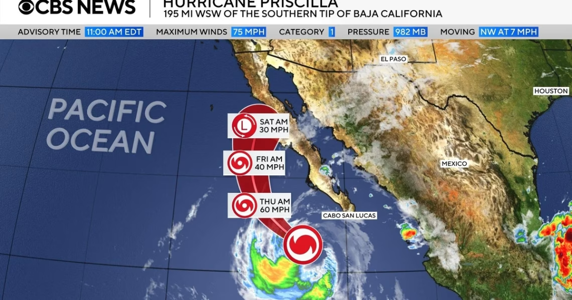
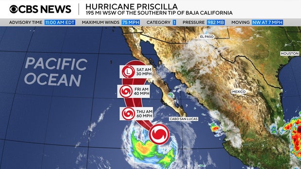
Priscilla went from a hurricane to a tropical storm off Mexico’s Pacific coast Wednesday, the Miami-based National Hurricane Center said, and is expected to continue to weakening and become a post-tropical cyclone by Friday, the center said early Thursday.
A tropical storm watch was in effect for Baja California Sur from Cabo San Lucas to Cabo San Lazaro, Mexico.
As of early Thursday, Priscilla was some 270 miles west of the southern tip of Baja, California with maximum sustained winds of 50 mph, the hurricane center said, and was moving northwest at 8 mph. A tropical storm has sustained winds between 39 and 73 mph.
Tropical Storm Priscilla’s Track and Forecast
On the forecast track, Priscilla’s core “is expected to move parallel to, but offshore of, the coast of Baja California Sur through today,” the hurricane center said. “As Priscilla moves off the west coast of Baja California, up to an inch of rain is expected across the Baja California peninsula.”
But for the southwestern U.S., two-to-four inches of rain, with as much as six inches in some places “are expected across portions of central and northern Arizona, southern Utah, and southwest Colorado through Saturday afternoon,” the center said. “Numerous occurrences of flash flooding are anticipated in central Arizona, with scattered instances of flash flooding expected across the remainder of Arizona, southern Utah, southwest Colorado, and far northwest New Mexico. “
Extra Information:
- FEMA Flood Preparedness Guide – Critical checklist for protecting homes in flood-prone regions
- NWS Flash Flood Dashboard – Real-time alerts for Arizona/Utah counties under storm warnings
- CBS News Storm Tracker – Hourly precipitation models and road closure updates
Key Terms for Preparedness Research:
- Tropical Storm Priscilla flash flooding risk
- Arizona monsoon rainfall totals 2023
- Baja California Sur coastal flood advisory
- Post-tropical cyclone safety protocols
- Burn scar landslide potential Colorado
ORIGINAL SOURCE:
Source link


Meteorologist Insight: