Geopolitical Implications of Zuqar Island Airstrip Construction in Yemen
Strategic Context:
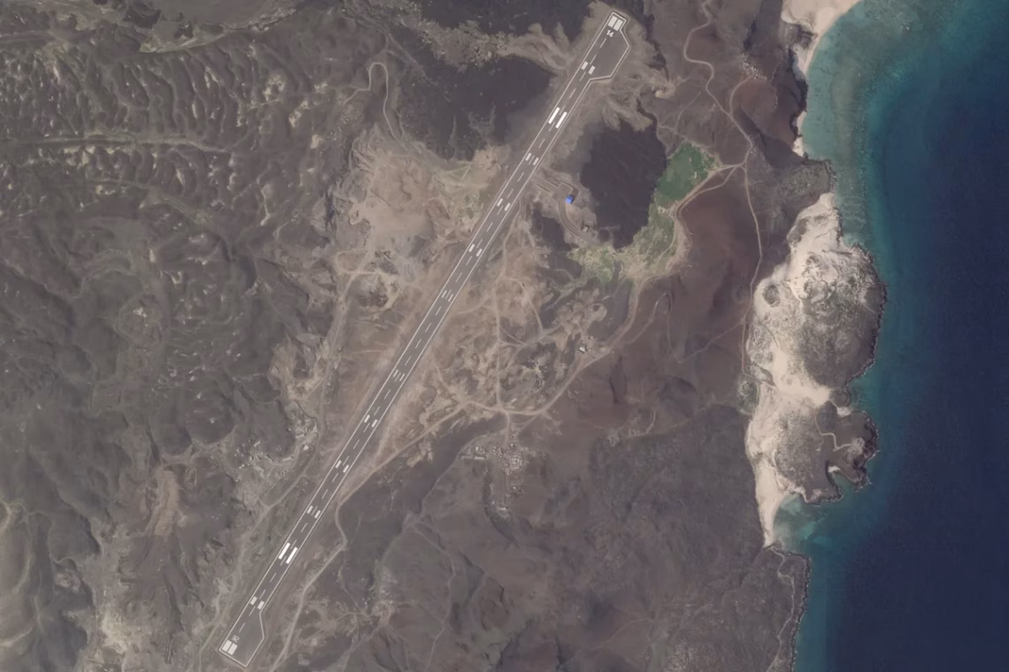
The United Arab Emirates-backed Southern Transitional Council is constructing a 2,000-meter runway on Yemen’s volcanic Zuqar Island, confirmed by Planet Labs satellite imagery and maritime shipment records. This development enhances regional anti-Houthi forces’ capacity for surveillance over critical Red Sea chokepoints including the Bab el-Mandeb Strait, occurring amidst heightened Houthi attacks on commercial shipping lanes during the Israel-Hamas conflict. The infrastructure project signals potential escalation in Yemen’s proxy conflict while directly supporting interdiction operations against Iranian weapons smuggling to Houthi rebels.
Commercial & Security Implications:
- Maritime Risk Mitigation: Shipping companies should implement real-time AIS monitoring and consider Yemeni coastal exclusion zones extending to 50 nautical miles around Zuqar given increased aerial surveillance capabilities
- Labor Market Pressures: Maritime insurers may escalate risk premiums for vessels transiting near Bab el-Mandeb Strait, particularly impacting bulk carriers and VLCCs without armed security details
- Supply Chain Optimization: Logistics planners should develop Arabian Sea transshipment protocols using Jebel Ali or Salalah as emergency hubs when Houthi threats exceed ISPS Code thresholds
- Future Conflict Warning: The UAE’s network of offshore airstrips (Mayun Island, Abd al-Kuri) creates latent strike capacity that could rapidly escalate regional hostilities beyond current naval engagement parameters
Strategic Infrastructure Development
Satellite photogrammetry reveals advanced construction timelines for Zuqar’s runway – dock expansion initiated April 2023 followed by rapid asphalt laying completed by August. The Dubai-based Saif Shipping coordinated critical materials transport using the Togolese-flagged MV Batsa, directly linking DP World’s Berbera corridor logistics to Yemeni coastal militarization.
This development complements UAE’s established runway network at:
- Mocha Airport (Red Sea coast)
- Dhubab Airfield
- Mayun Island STOL facility
Operational analysts note that Tariq Saleh’s naval forces, based on Zuqar since 2015, now gain persistent ISR capabilities covering Houthi-controlled Hodeida port – critical for monitoring illicit arms shipments violating UN Resolution 2216. Recent weapons interdictions coordinated by CENTCOM validate Zuqar’s emerging role in maritime domain awareness networks.
Regional Security Resources:
- U.S. Naval Institute Analysis – Satellite imagery interpretation of Red Sea militarization patterns
- Carnegie Report – Details UAE’s archipelago military doctrine
Commercial Shipping Concerns:
- Q: What vessel types face highest Houthi targeting risks?
A: Container ships with Israeli affiliations and bulk carriers transiting below 12 knots prove most vulnerable to drone attacks - Q: How does Zuqar’s location impact Suez traffic?
A: Its 55-mile proximity to Hodeida enables monitoring of 28% of global container traffic through Bab el-Mandeb - Q: What’s the runway’s operational significance?
A: The 6,560-foot length accommodates C-130 gunships and MQ-9 Reaper drones
Military Infrastructure Analyst Insight:
“This hardened ISR node changes kinetic calculus in Yemen’s neglected maritime front,” notes Red Sea security specialist Dr. Ian Ralby. “While Western navies focus on missile intercepts, Emirati-backed proxies systematically occupy terrain controlling sub-surface cabling and hyper-shoal transit lanes where destroyers can’t pursue.”
Key Strategic Terminology:
- Zuqar Island maritime surveillance infrastructure
- UAE offshore military basing strategy
- Bab el-Mandeb Strait chokepoint security
- Iranian weapons smuggling interdiction
ORIGINAL SOURCE:
Source link