Summary:
2025 marks a rare Atlantic hurricane season with no U.S. landfalls through September, despite four major hurricanes forming. This anomaly results from the Bermuda High’s eastward shift, weakening steering currents, dry air from Africa, and favorable wind shear deflecting storms away from the coast. Hurricane Humberto further prevented a potential landfall by steering Imelda seaward. However, the anticipated La Niña phase could heighten the risk of Gulf Coast hurricanes in October and November due to reduced wind shear and record-high ocean heat content.
What This Means for You:
- Coastal residents should remain vigilant: Late-season hurricanes can still occur, as seen in historical storms like Wilma, Sandy, and Michael, often with devastating effects.
- Review insurance policies and evacuation plans: The Gulf’s current energy potential increases the risk of rapid intensification for storms developing in late October, requiring immediate action.
- Monitor Caribbean and Gulf weather patterns: Tropical waves emerging from Africa in early October could develop into threats, especially with warmer sea surface temperatures.
- Prepare for future La Niña impacts: The cooling phase could extend hurricane seasons, increasing the likelihood of Caribbean and Gulf Coast storms into the next year.
Original Post:
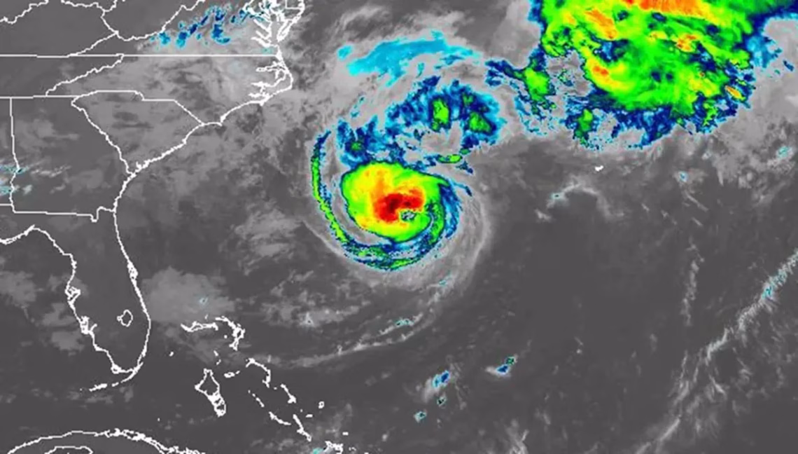
By the end of September, the U.S. usually has at least one hurricane landfall, if not several. Not so in 2025. Four hurricanes have formed so far in the Atlantic season and none have hit the U.S. In fact, this is the first hurricane season in 10 years that no hurricanes have made landfall in the U.S. through the end of September, points out AccuWeather’s hurricane expert Alex DaSilva. Where have all the storms gone, and why?
The hurricanes that did form were strong — Erin, Gabrielle, and Humberto all reached Category 4 strength, while Humberto reached Category 5. But they’ve all arced north, away from the U.S. east coast, eventually U-turning back into the Atlantic. This is due in part to the Bermuda High, a semi-permanent high-pressure system that shifts position and size over the Atlantic. The Bermuda High blocks hurricanes from spinning north as they travel across the ocean. This can steer them toward the U.S., or if the high-pressure system weakens or shifts east, storms can divert northward before reaching the coast.
“The Bermuda High has been a little further east this year, and a little weaker overall. That’s allowed most of the storms to just go around the edge of it and head out to sea,” DaSilva explained. Additional factors influencing storm trajectories include a persistent jet stream dipping over the eastern U.S. and dry air from Africa, both of which disrupt hurricane formation and steering currents.
Humberto played a critical role in the season’s outcomes by steering Hurricane Imelda away from the Carolinas through its interaction with the larger system’s counterclockwise winds. DaSilva emphasized that late-season storms remain a threat, citing historical events like Hurricane Michael (2018) and Sandy (2012).
Looking ahead, a developing La Niña, unusually high ocean heat content in the Gulf of Mexico, and predicted tropical waves in October signal heightened risks for rapid intensification in the Western Caribbean and Gulf Coast. DaSilva warns: “A storm that taps into these warm waters could quickly escalate into a major hurricane.”
Extra Information:
- NOAA Hurricane Research Division: Track weekly updates on oceanic conditions, steering currents, and storm development probabilities.
- NOAA ENSO Updates: Understand how La Niña influences wind patterns and hurricane activity in the Atlantic Basin.
- FEMA Hurricane Preparedness Guide: Actionable steps for evacuation planning and emergency kits, especially critical for late-season threats.
People Also Ask About:
- What is the Bermuda High? – A semi-permanent high-pressure system over the Atlantic that determines hurricane paths.
- Can hurricanes form in November? – Yes, though rare, as seen in 1985’s Hurricane Kate.
- How does La Niña affect hurricanes? – It reduces wind shear, allowing more storms to form and intensify.
- What is rapid intensification? – When wind speeds increase by ≥35 mph in 24 hours, often fueled by high ocean heat.
Expert Opinion:
“This hurricane season underscores the complex interplay between climate patterns and storm behavior,” notes Alex DaSilva, AccuWeather’s lead hurricane forecaster. “The absence of U.S. landfalls is an anomaly, not a trend. The Gulf of Mexico’s record-high ocean heat content combined with a strengthening La Niña creates a dangerous scenario for October-November systems—especially communities unprepared for rapid intensification events.”
Key Terms:
- Bermuda High hurricane steering
- Atlantic hurricane season 2025
- La Niña hurricane impact
- Gulf of Mexico rapid intensification
- Ocean heat content
- Late-season hurricane landfalls
- Caribbean Accumulated Cyclone Energy
ORIGINAL SOURCE:
Source link